Ергаки. Каменный город
Давно я не писал о каменных чудесах. Этой статьей возвращаюсь к данной теме.

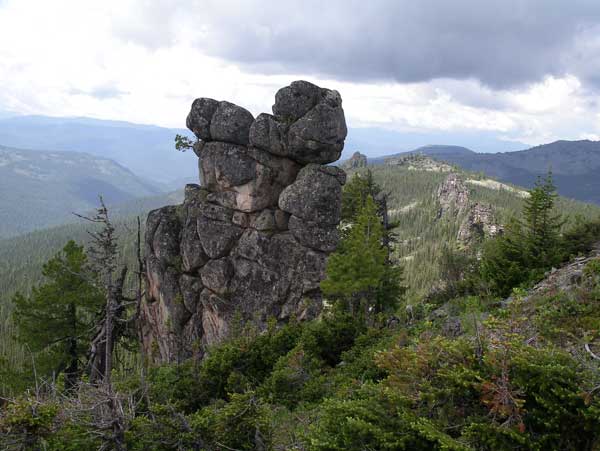
Ергаки. Каменный город. Страж.
Координаты 52° 52' 8.12" N 92° 57' 29.05" E. Ссылка на карту
Уникальный геологический объект (УГО). Решение постановления Совета администрации Красноярского края, № 341-п, 2.11.2006 г. Примерная площадь: 20 Га

От трассы М54 до этого места - около 30км. Есть дорого через п.Тазынбей, но, возможно, она хуже

Доехать сюда можно на автомобиле, лучше, конечно, на полноприводном с повышенным клиренсом.

Дорога представляет из себя вот такой вид.


Если приблизить этот горный массив, то увидим, что в гугл-картах часть снимка с космоса «затерта», в пикселях. В других картах не проверял.

У подножья гор вот такой крупный курумник - это то, что осталось от разрушения «каменного города» землятресениями или еще чем.

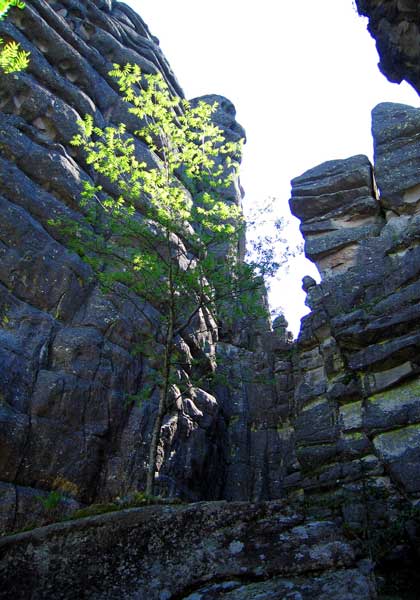
Давайте посмотрим на фотографии с этого места без всяких комментариев и каждый для себя решит, делала это природа или другие силы:


По поводу всего этого места есть вот такое мнение: Д.Т.Туэло: «Ергаки» Созданы руками человека
Этим летом здесь побывал А.Кунгуров. Вот его мнение: ссылка
Источники фотографий:
[Spoiler (click to open)]http://www.panoramio.com/user/5254511?with_photo_id=95357903
http://www.geomem.ru/mem_obj.php?id=13494
Ергаки. Каменный город. Страж.
Координаты 52° 52' 8.12" N 92° 57' 29.05" E. Ссылка на карту
Уникальный геологический объект (УГО). Решение постановления Совета администрации Красноярского края, № 341-п, 2.11.2006 г. Примерная площадь: 20 Га
От трассы М54 до этого места - около 30км. Есть дорого через п.Тазынбей, но, возможно, она хуже
Доехать сюда можно на автомобиле, лучше, конечно, на полноприводном с повышенным клиренсом.
Дорога представляет из себя вот такой вид.

Если приблизить этот горный массив, то увидим, что в гугл-картах часть снимка с космоса «затерта», в пикселях. В других картах не проверял.
У подножья гор вот такой крупный курумник - это то, что осталось от разрушения «каменного города» землятресениями или еще чем.
Давайте посмотрим на фотографии с этого места без всяких комментариев и каждый для себя решит, делала это природа или другие силы:
По поводу всего этого места есть вот такое мнение: Д.Т.Туэло: «Ергаки» Созданы руками человека
Этим летом здесь побывал А.Кунгуров. Вот его мнение: ссылка
Источники фотографий:
[Spoiler (click to open)]http://www.panoramio.com/user/5254511?with_photo_id=95357903
http://www.geomem.ru/mem_obj.php?id=13494